NOAA Predicts Active 2025 Atlantic Hurricane Season
NOAA forecasts an above-normal 2025 hurricane season with 17–25 named storms. Stay prepared with updates and tips from trusted emergency resources.
NOAA predicts above-normal 2025 Atlantic hurricane season
Above-average Atlantic Ocean temperatures set the stage
May 22, 2025 — Forecasters within NOAA’s National Weather Service predict above-normal hurricane activity in the Atlantic basin this year.
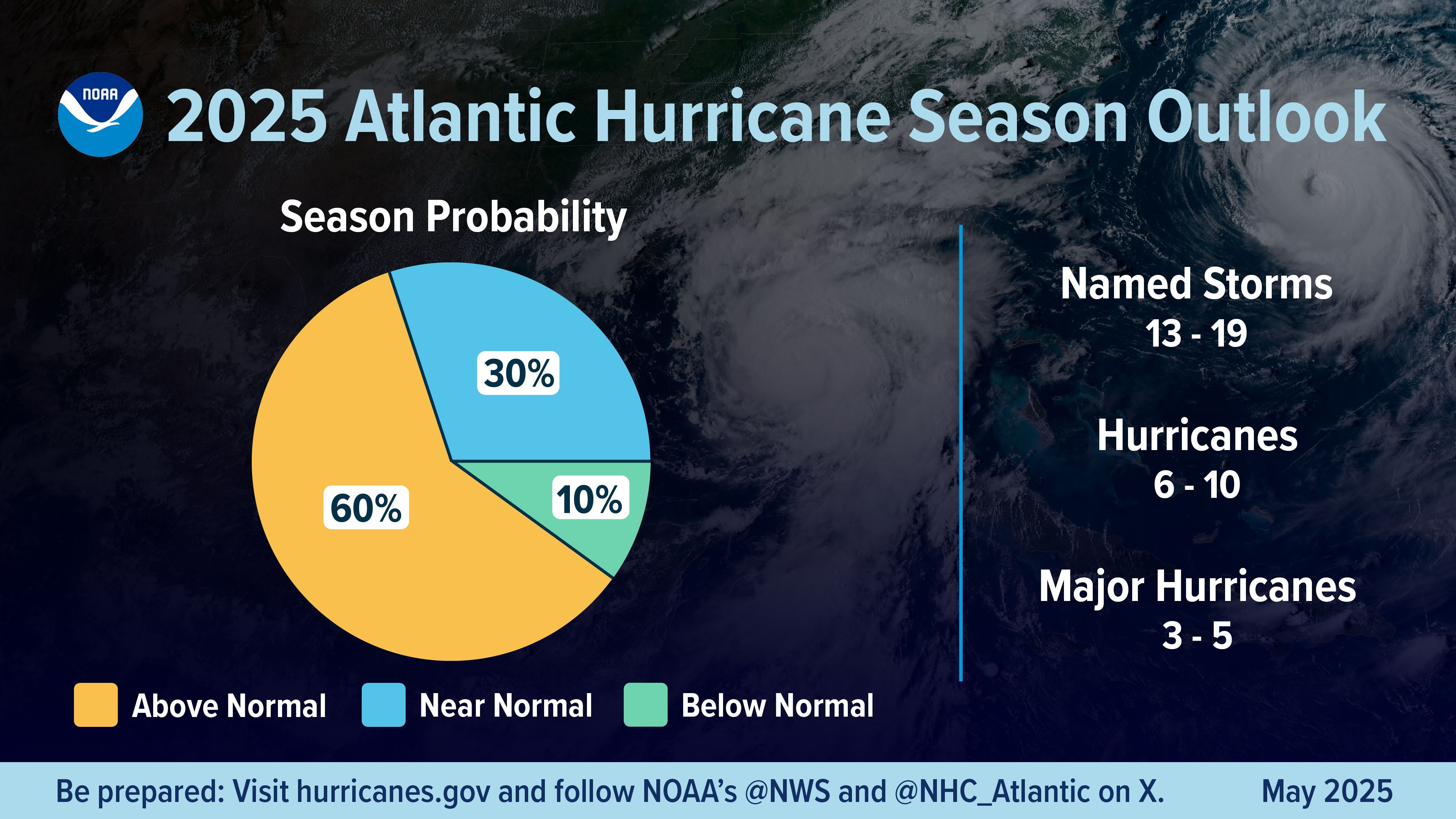
NOAA’s outlook for the 2025 Atlantic hurricane season, which goes from June 1 to November 30, predicts a 30% chance of a near-normal season, a 60% chance of an above-normal season, and a 10% chance of a below-normal season.
The agency is forecasting a range of 13 to 19 total named storms (winds of 39 mph or higher). Of those, 6-10 are forecast to become hurricanes (winds of 74 mph or higher), including 3-5 major hurricanes (category 3, 4 or 5; with winds of 111 mph or higher). NOAA has a 70% confidence in these ranges.
“NOAA and the National Weather Service are using the most advanced weather models and cutting-edge hurricane tracking systems to provide Americans with real-time storm forecasts and warnings,” said Commerce Secretary Howard Lutnick. “With these models and forecasting tools, we have never been more prepared for hurricane season.”
“As we witnessed last year with significant inland flooding from hurricanes Helene and Debby, the impacts of hurricanes can reach far beyond coastal communities,” said Acting NOAA Administrator Laura Grimm. “NOAA is critical for the delivery of early and accurate forecasts and warnings, and provides the scientific expertise needed to save lives and property.”

A summary infographic showing hurricane season probability and numbers of named storms predicted, according to NOAA's 2024 Atlantic Hurricane Season Outlook. The official start of the Atlantic hurricane season is June 1 and runs through November 30. (See also news release text for data found within above graphic.) (Image credit: NOAA NWS)
Factors influencing NOAA’s predictions
The season is expected to be above normal – due to a confluence of factors, including continued ENSO-neutral conditions, warmer than average ocean temperatures, forecasts for weak wind shear, and the potential for higher activity from the West African Monsoon, a primary starting point for Atlantic hurricanes. All of these elements tend to favor tropical storm formation.
The high activity era continues in the Atlantic Basin, featuring high-heat content in the ocean and reduced trade winds. The higher-heat content provides more energy to fuel storm development, while weaker winds allow the storms to develop without disruption.
This hurricane season also features the potential for a northward shift of the West African monsoon, producing tropical waves that seed some of the strongest and most long-lived Atlantic storms.
“In my 30 years at the National Weather Service, we’ve never had more advanced models and warning systems in place to monitor the weather,” said NOAA’s National Weather Service Director Ken Graham. “This outlook is a call to action: be prepared. Take proactive steps now to make a plan and gather supplies to ensure you're ready before a storm threatens."
Improved hurricane analysis and forecasts in store for 2025
NOAA will improve its forecast communications, decision support, and storm recovery efforts this season. These include:
- NOAA’s model, the Hurricane Analysis and Forecast System, will undergo an upgrade that is expected to result in another 5% improvement of tracking and intensity forecasts that will help forecasters provide more accurate watches and warnings.
- NOAA’s National Hurricane Center (NHC) and Central Pacific Hurricane Center will be able to issue tropical cyclone advisory products up to 72 hours before the arrival of storm surge or tropical-storm-force winds on land, giving communities more time to prepare.
- NOAA’s Climate Prediction Center’s Global Tropical Hazards Outlook, which provides advance notice of potential tropical cyclone risks, has been extended from two weeks to three weeks, to provide additional time for preparation and response.

The alphabetical list of 2025 Atlantic hurricane names as chosen by the World Meteorological Organization. Find a text version of this list at hurricanes.gov/aboutnames.shtml#atl (Image credit: NOAA NWS)
Enhanced communication products for this season
- NHC will offer Spanish language text products to include the Tropical Weather Outlook, Public Advisories, the Tropical Cyclone Discussion, the Tropical Cyclone Update and Key Messages.
- NHC will again issue an experimental version of the forecast cone graphic that includes a depiction of inland tropical storm and hurricane watches and warnings in effect for the continental U.S. New for this year, the graphic will highlight areas where a hurricane watch and tropical storm warning are simultaneously in effect.
- NHC will provide a rip current risk map when at least one active tropical system is present. The map uses data provided by local National Weather Service forecast offices. Swells from distant hurricanes cause dangerous surf and rip current conditions along the coastline.
Innovative tools for this year
- NOAA National Environmental Satellite, Data, and Information Services (NESDIS), in collaboration with NOAA’s Office of Marine and Aviation Operations and NOAA Research, is deploying a new, experimental electronically scanning radar system called ROARS on NOAA’s P-3 hurricane hunter research aircraft. The system will scan beneath the plane to collect data on the ocean waves and the wind structure of the hurricane.
- NOAA Weather Prediction Center’s experimental Probabilistic Precipitation Portal provides user-friendly access to see the forecast for rain and flash flooding up to three days in advance. In 2024, Hurricane Helene caused more than 30 inches of extreme inland rainfall that was devastating and deadly to communities in North Carolina.
NOAA’s outlook is for overall seasonal activity and is not a landfall forecast. NOAA also issued seasonal hurricane outlooks for the eastern Pacific and central Pacific hurricane basins. NOAA’s Climate Prediction Center will update the 2025 Atlantic seasonal outlook in early August, prior to the historical peak of the season.
Article Link: https://www.noaa.gov/news-release/noaa-predicts-above-normal-2025-atlantic-hurricane-season
Media contact: National Weather Service Public Affairs, nws.pa@noaa.gov